Organized crime networks -- or mafia -- stretched across the U.S. in the 1960s. Researchers used geographic information systems to investigate how these networks were shaped and how they shaped organized crime during the mafia's organizational height. Image: Penn State
GIS technology helps map out how America’s mafia networks were ‘connected’
Posted on April 13, 2021UNIVERSITY PARK, Pa. — At its height in the mid-20th century, American organized crime groups, often called the mafia, grossed approximately $40 billion each year, typically raising that money through illegal or untaxed activities, such as extortion and gambling.
A team of researchers used geographic information systems — a collection of tools for geographic mapping and analysis of the Earth and society — and data from a government database on mafia ties during the 1960s, to examine how these networks were built, maintained and grown. The researchers said that this spatial social networks study offers a unique look at the mafia’s loosely affiliated criminal groups. Often called families, these groups were connected — internally and externally — to maintain a balance between security and effectiveness, referred to as the efficiency-security tradeoff.
“In this type of network, there are two competing prerogatives,” said Daniel DellaPosta, assistant professor of sociology and social data analytics and affiliate of the Institute for Computational and Data Sciences. “The first is that you want your organization to be structured in a way that allows for effective communication between members, so that they can coordinate their behaviors to achieve goals for the group. However, the second prerogative is security. In a covert network like this, which is trying to evade detection from authorities, you might not want your network to be too well connected because then if one member gets captured, they could implicate a lot of others.”
The team investigated this tradeoff by analyzing two specific metrics in the mafia’s network connections, according to Clio Andris, assistant professor of city and regional planning and interactive computing, Georgia Tech.
“The efficiency security tradeoff helped us ground the hypothesis that the mafia was optimizing their organization for something,” said Andris, who used the mafia data as a case study in graduate seminar in her former role as a Penn State faculty member. “We didn’t find a value that we could say how optimized it was, but we were able to use two metrics together to measure optimization. One metric measured how much the network was clustered and the other measured the number of intermediary connections — or ‘hops’ — between people. We can make those hops into the distance between people.”
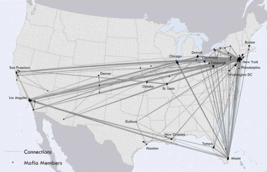
As one example of that geographic concentration, the researchers found that at least 80% of members in each of New York City’s five major crime families — Profaci, Gambino, Genovese, Lucchese and Bonnano — lived within about 18.5 miles of their family’s median center in the city. High-ranking members tended live near the center of those areas.

Mafia networks needed to be close enough to maintain order and facilitate communication — but they couldn’t be too close, or a single arrest could topple the entire organization, according to researchers. IMAGE: Penn State
The researchers, who report their findings in a recent issue of the International Journal of Geographical Information Science, also examined the mafia’s networks in both incorporated and nonincorporated cities. In incorporated cities, like New York City, the mafia families tended to operate in distinct neighborhoods, or “turf.” However, in nonincorporated, or open, cities, such as Miami, many different families could operate on the same turf. All five of New York City’s families sent representatives to Miami, lured there by the growing gambling rackets, the researchers suggested.
The data suggested that a mafia member’s connections may have played some role in whether a member was dispatched to the Florida city or not. According to Andris, the people who were sent to Miami tended to be people with limited connections mixed in with a group of better connected — but not optimally connected — people.
According to DellaPosta, the team’s findings could have implications for criminology in general, but also for law enforcement practices today.
“Even though our data is from 1960, many of the families in the data are still around in some fashion today,” said DellaPosta. “There’s reason to think that they organize in a fairly similar way. What we add to that narrative in this paper is the geographic and spatial dimension, as well, which might be important, especially in coordinating efforts across multiple law enforcement agencies.”
The researchers used a database of 680 mafia members taken from a 1960 dossier compiled by the U.S. Federal Bureau of Narcotics. The data included connections between members of the mafia geolocated to a known home address in 15 major U.S. cities.
The study started as a lesson in Andris’s graduate seminar in GIS while she was a faculty member at Penn State.
“This project was a cool opportunity to use a unique data source and a novel analysis strategy to think about how people use geographic space,” said Brittany Freelin, graduate student sociology and criminology, who worked with Andris and DellaPosta on the project. “The mafia data allowed us to map mafia member’s addresses and the spatial social networks approach enabled analyses of how those mafia members were distributed across U.S. cities, which allowed us to simultaneously examine the spatial and social network elements of the data.”
The team also included Xi Zhu, a former postdoctoral scholar in the GeoVISTA Center; Bradley Hinger, doctoral student in geography; and Hanzhou Chen, a former graduate assistant in geography, all of Penn State.